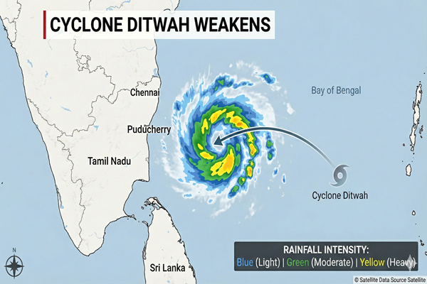
Cyclone Ditwah has fully weakened into a deep depression near the Tamil Nadu–Puducherry coastline, with the system now stalling close to land and expected to weaken further into a depression within hours. Despite losing cyclone strength, the system continues to generate moderate to heavy rainfall, especially across northern Tamil Nadu and coastal Andhra Pradesh.
Current Position (Latest IMD Update)
-
90 km south-southeast of Chennai
-
90 km east-southeast of Puducherry
-
110 km east-northeast of Cuddalore
-
180 km north-northeast of Karaikal
-
Estimated 50 km offshore from Tamil Nadu–Puducherry coastline.
The system has slowed significantly and is expected to remain nearly stationary for the next 24 hours.
Observed & Forecast Rainfall Impact
Rainfall has been recorded across multiple districts, including:
✔ Chennai
✔ Thiruvallur
✔ Kancheepuram
✔ Cuddalore
✔ Ranipet
More rainfall is expected as the system lingers over the southwest Bay of Bengal.
| Region | Forecast | Duration |
|---|---|---|
| North Tamil Nadu | Moderate–Heavy rain | Next 24 hours |
| Puducherry & Karaikal | Scattered rain | Ongoing |
| Coastal Andhra Pradesh | Heavy rain in pockets | Next 24–48 hrs |
| Rayalaseema & Telangana | Light–Moderate rain | Next 48 hrs |
| Kerala & South Interior Karnataka | Thunderstorms | 48–72 hrs |
Marine & Transportation Advisory
The IMD continues to warn against marine activities:
🚫 Fishing ban continues
🚫 Do not enter:
-
Southwest Bay of Bengal
-
Gulf of Mannar
-
Tamil Nadu–Puducherry coast
-
Andhra Pradesh coastal waters
-
Sri Lanka marine belt
Port movement may experience temporary disruption and cargo handling delays at:
-
Chennai
-
Ennore
-
Cuddalore
-
Kakinada
Crop & Logistics Implications
-
Harvesting delays expected for rice, groundnut, and vegetables.
-
Moisture benefit likely for rabi crops such as millets and pulses if field drainage remains adequate.
-
Possible urban flooding risk in Chennai and coastal districts due to slow system movement.
Outlook
Ditwah has lost cyclone intensity but remains a slow-moving rain-bearing system. Continued monitoring is required due to its stationary pattern, which can increase localized rainfall intensity.
Further weakening into a depression is expected by noon on December 1.
CMB Weather Desk will issue further updates as IMD releases new bulletins.